

Researching the Swiss writer Annemarie Schwarzenbach led me to investigate her family’s silk business. Her grandfather, Robert Schwarzenbach, was nicknamed “the silk king” and was the biggest silk producer in the world at the close of the nineteenth century, with branches of the family firm in Switzerland, Milan, New York, Buenos Aires and France. One of the French factories was in Huningue, just across the border from me here in Basel. It’s a region called the Dreiländereck, a tripoint, trijunction, triple point, or tri-border area where three countries meet – France, Germany and Switzerland. This afternoon I crossed the border and walked around Huningue to see if there was anything left of Robert Schwarzenbach the silk king, but precious little emerged.

Huningue is right on the border with Basel, handy if you want to employ cheaper factory labour. It’s also between the river, and the Canal de Huningue, a branch of the Canal du Rhône et Rhin, a water network which would have been useful for a cloth factory. From the above 1901 postcard, we can see that the factory was opposite the train station, now a pharmacy. The branch line has in the interim century shut down and the tracks are covered in weeds but the former train station still has the same basic shape and mansard roof with dormer windows.

The “Wohnhaüser” – employees’ houses – depicted in the inset of the above postcard are still there on rue de Belfort, tarted up a bit but looking somewhat worse for wear, and with characteristic Alsatian bombe wrought iron balconies of the Art Nouveau period. The magnificent trees lining the road have gone, though, and new building work is underway where the factory buildings used to be.
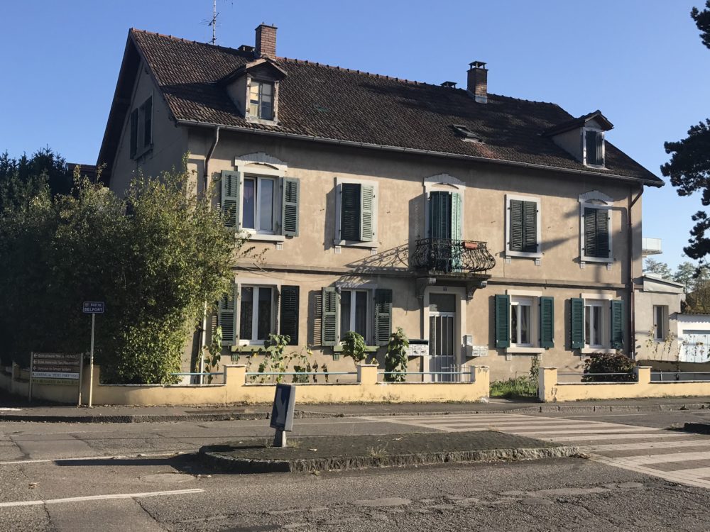
Former “Wohnhaüser- or employees’ houses – of the Schwarzenbach silk factory, Huningue.
This part of Huningue is built over the underground remains of the old star-shaped fort, a smaller version of the one at Belfort, testifying to the strategic importance of Huningue in this corner of France abutting Switzerland with Germany across the Rhine. The storerooms under the fort kept provisions in case of a siege – powder for cannon, fodder for horses, lard for the humans. The fort was built by Vaubin under Louis XIV between 1679 and 1681. A rue Vaubin still runs down to the river.
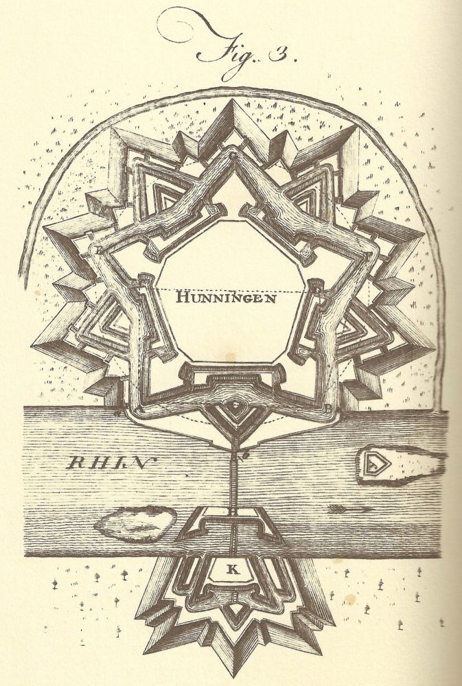
Fortification of Huningue, Encyclopaedia Brittanica
A notice at the entrance to the underground storerooms fleshes out the history. Rue du Rempart, rue de la Poudrière, and a big grassy empty area on Google Maps are all that’s left above ground of the former fort. By my estimation, the location of the tall factory chimney in the above postcard must have been right above the northern point of the old fort. The center of the fort is the present-day Place Abbatucci, named for a Corsican-born general in the French Revolution who died at Huningue.
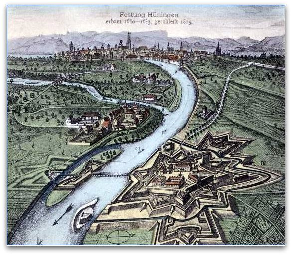
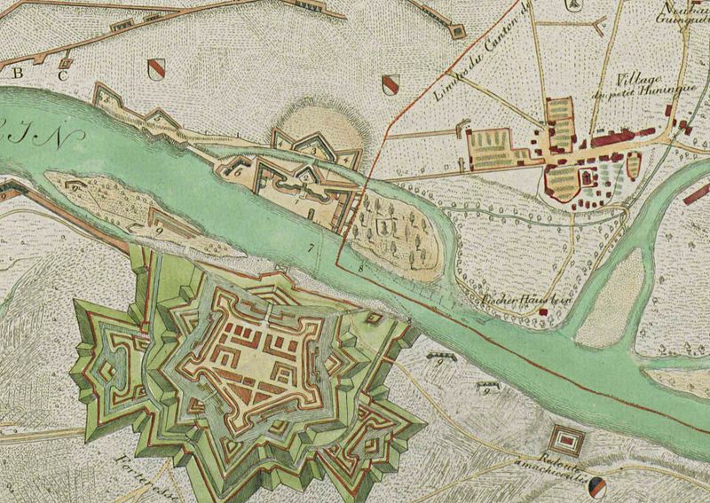
A View of the Rhine river at Huningue, with Basel in the background, 1680.
Between the Franco-Prussian War of 1870 and the First World War, Huningue was part of the German Empire. Between the world wars it reverted to France, which I presume is when the Schwarzenbach factory was demolished. It was taken by Germany again in 1940 until the end of the Second World War. The imposing fort was always a sore point with the Swiss, especially so since a part of it (marked K above) was across the river too close to Basel territory for comfort. Old maps show an island there, and a village had been cleared to construct the fortifications. During three sieges of the city, in 1796-1797, 1813-1814, and 1815, the Swiss demolished the part of the fort on the other side of the river and the connecting bridge, as can be seen in the commemorative watercolour below.

French evacuation, 1797, Huningue fort across the river, watercolour by Christian von Mechel (Zentralbibliothek Zürich, Graphische Sammlung und Fotoarchiv).
The Rheinpark Restaurant which occupies the site of the fortifications on the German side of the river has maintained the star-shaped design of the original fort – so perhaps it was built on solid older foundations. Where the pontoon fording bridge used to be, allowing troops to transport supplies, there is now the Passerelle des Trois Pays or the Dreiländerbrücke or the Three Countries Bridge – the longest single-span pedestrian bridge in the world at 248 meters. It replaces the pedestrian pontoon bridge on the same location which was bombed by the Allies in 1944.

The old fording bridge between Huningue and Weil am Rhein, bombed by the Allies in 1944.
I went back to Huningue the next day and had a tagine with dates and almonds and some fine Algerian wine (Coteaux de Mascara, which I’d last drunk in 1978-79) for lunch, in La Couscoussiere (highly recommended). Then I headed off across the pedestrian bridge over the river.
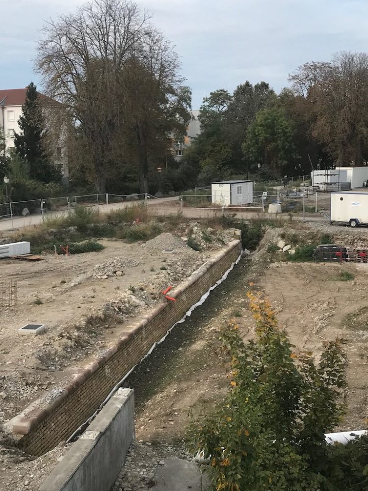
The old fortification wall unearthed at Huningue.
On the French side a big landscaping project is well underway, developing the river park and uncovering the retaining wall of the fortress – surprisingly made of brick. Somehow I had imagined stones. The capping stones were that red sandstone used in many public buildings – cathedrals, churches, town halls – in Baden and along the Rhine.
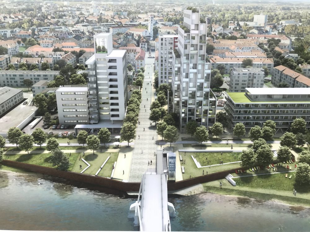
An infographic of the future riverside park at Huningue, with the old fortress walls clearly uncovered.
On the German side there was little trace of the fortifications in the dirty little park by the river. It too is slated for development in a fit of entente cordiale. A Chinese restaurant sits on the old fort foundations and that modern appeasement – the shopping mall – dominates the former island. My guess is that the foundations of the fort are under the mall, in the car park.
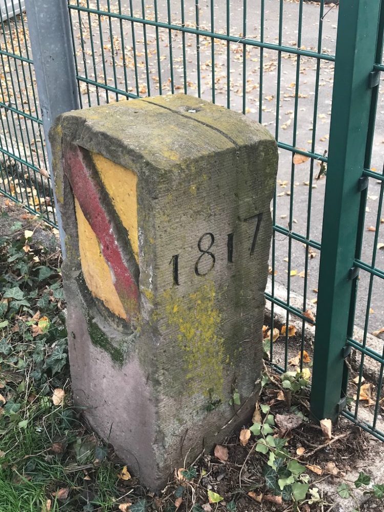
Boundary stone No. 1 on the German-Swiss border at Weil am Rhein.
Along the river and round the back of the mall I spotted a magnificent boundary stone, dating from 1817, marking the German-Swiss border. On the other facet of the stone is marked No.1. It sports the coat of arms of the Grossherzogtum Baden, the Grand Duchy of Baden. Jewish refugees sometimes attempted to swim across to Switzerland from here during the war.
The fortifications at Huningue, 1797, drawing by Charles Pinot & Christian von Mechel
The Schwarzenbach factory was established in Huningue, therefore, when it was under German control between 1871 and 1918, and the Germans were favourable to Swiss involvement in industrial expansion. So perhaps the paucity of remains of the factory is because it was established on the German watch and obliterated when the town reverted to France. In the postcard below you can clearly see the extensive size of the factory, the line of the Rhine river and the range of the Black Forest across the way in Germany. The new houses obliterate the earlier factory which covers over the former fort: the battle for memory is on.

Postcard of Huningue train station and the Schwarzenbach silk factory, 1917.

Flier for the Schwarzenbach silk enterprise at the height of its fame.